
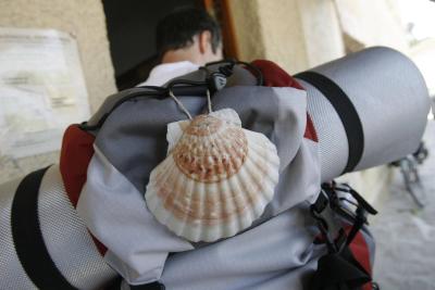
The French Way of St James
 Luzaide/Valcarlos
The most well-known route enters Navarre through the Pyrenees via Luzaide/Valcarlos, some kilometres before Orreaga/Roncesvalles.
Its main attractions: This Route uncovers enclaves such as the Collegiate of Orreaga/Roncesvalles; spectacular landscapes that span from the Pyrenees to the Middle Zone, passing through the city of Pamplona; and some of the most outstanding artistic monuments on the Route.
The landscape gradually changes. We set off in Pyrenean woods, between beech and oak trees, and green meadows dotted with small hamlets with steep roofs. The Pamplona Basin changes the scenery, and as we advance through the Middle Zone, the fi elds gradually fi ll with crops, vineyards, olive groves and almond orchards. The route uncovers memorable monuments: Pamplona’s churches and cathedral, the Puente la Reina bridge, San Pedro de la Rúa church in Estella-Lizarra, the Santo Sepulcro in Torres del Río, and the walls of Viana.
Sections
French Route: St. Jean-Pied-de-Port to Roncesvalles
N/A
9.05 km
229.0 m
Alta
The starting point is Saint Jean-Pied-de-Port, near Ostabat, where three of the major Santiago Way routes meet. Saint Jean-Pied-de-Port (or Donibane Garazi), is a small city that I had heard a lot about, and which exceeded all of my expectations. The Citadel is well worth a visit before heading off on the Way, as is the castle and Gothic church. Once you have seen the main attractions, leave the village along the Rue d’Espagne until you reach the Porte d’Espagne.
At this point you can choose between two routes: the fi rst is “Napoleon’s Route”, which is harder because it winds through the mountains, takes you to the Honto neighbourhood, crosses the Bentartea col and that of Lepoeder, and reaches the Ibañeta Peak to then descend down a steep, wooded area to Orreaga/Roncesvalles.
There are two different ways to complete this stage, though the most accessible and recommendable when the weather is bad – and for those that do not want to suffer too much – is the option that passes through Luzaide/Valcarlos. Between 1st November and 31st March this is the only possible route.


French Route: Luzaide/Valcarlos-Orreaga/Roncesvalles
N/A
16.57 km
908.0 m
Media
From Luzaide/Valcarlos onwards you will face the most demanding stretches. The path ascends between chestnut, birch and hazelnut trees, rivers, meadows and a beech forest that leads to the Ibañeta Peak, where the legend sets the Battle of Roncesvalles, made popular in the ‘Chanson de Roldán’.
Orreaga/Roncesvalles, the ideal haven From the Ibañeta peak, we head down to Orreaga/Roncesvalles through a valley. We reach our fi nal destination via an exceptionally beautiful wooded trail. This major religious hub hosts genuine treasures. The most outstanding is the Collegiate of Santa María, a former pilgrims’ hospital, home to the remains of King Sancho VII the Great.
.jpg "vista del pueblo de Luzaide/Valcarlos")
The French Way of St James. Roncesvalles-Zubiri
N/A
21.65 km
318.0 m
Media
The first kilometres run parallel to the road (N-135) then heads into a forest known as “Sorginaritzaga” or “Oak forest of the witches”.
The first village we encounter is Auritz/Burguete, a pretty location declared a Place of Cultural Interest, dominated by farmhouses with steep gabled and hipped roofs. The Route crosses the village centre along the San Nicolás high street.
After passing the San Nicolás church, we carry on to cross the river Urrobi over a wooden bridge. The landscape is impressive, with enormous meadows, little forests and streams, which can be crossed over rudimentary stepping-stones.
After various kilometres with several climbs, we catch a glimpse of the steep red roofs of Aurizberri/Espinal. Once again we see the image of a quaint village with houses facing the main street.
The difficulties begin. The route leads away from the Pyrenees and the climbs and peaks begin. The first is the Mezkiritz Peak (920 metres). Follow the yellow arrows and enjoy the impressive beech forest that will guide you to the next town, Bizkarreta-Gerendiain.
We head into the wooded area and pass the remains of Venta del Puerto on one side, a former lodging. Fortunately, the route is all downhill from here, but take care when walking over the loose stones.
At the end of the route stands the legendary mediaeval Zubiri bridge known as “The Rabies Bridge” because it was believed that animals that crossed under it were cured of rabies.

The French Way of St James : Zubiri-Pamplona
N/A
20.26 km
220.0 m
Media
This stage starts with the Bridge of Rabies, which you must cross to reach the industrial area of Zubiri. A stone track will lead you to two small villages: Ilarratz and Ezkirotz. Two kilometres further on we encounter Larrasoaña. The pilgrimage route continues to Akerreta. Head towards Zuriain, and following the Way directions, aim for Irotz, where you will discover the Romanesque bridge of Iturgaiz (12th century). Follow directions carefully because there is a fork at this point of the route. You have to take the way that indicates Arre/Villava/Pamplona, which will take you to the Pamplona District River Park.
After crossing a picnic area, and avoiding the Pamplona (East Circuit) ring road through an underground walkway, you will reach the hermitage of Trinidad of Arre and its bridge, of possible Roman origin.
The pilgrimage route passes down the Calle Mayor of Villava. Continue along the Calle Mayor of Burlada until you cross the N-121. At this point it is important to follow the pilgrimage directions on the pavement, which will take you to the “Burlada Route”, the access point to Pamplona, the first city along the Way. The route is initially lined with trees, and then you must continue along a pavement on the narrow road till you reach the mediaeval bridge of the Magdalena. Cross the ancient fortifications and enter the historical city centre via the Portal of France drawbridge, a small 1553 treasure, which still boasts its original structure. The Portal leads visitors straight to the historical part of Pamplona.

The French Way of St James: Pamplona-Puente la Reina
N/A
23.75 km
405.0 m
Media
The route starts along the streets of the old part of Pamplona. After visiting the Cathedral of Santa María and heading down to the Calle Mercaderes and Calle Estafeta you will reach the Town Hall Square. Carry on down San Saturnino Street and enter the beautiful Romanesque church that gives its name to the street. The Condestable palace marks the start of the Calle Mayor street, where you will find the Ultreia - Way of St James Interpretation
Centre. The route continues towards Taconera Park and the city’s more open spaces. From Avenida Pío XII Avenue, head towards the Vuelta del Castillo, a beautiful green belt that surrounds La Ciudadela citadel.
After leaving the green area behind, you will be directed along Calle Fuente del Hierro and down towards the University of Navarre. From here follow a pavement that ascends to reach the village of Cizur Menor, where you will find some mediaeval treasures such as the Romanesque churches of San Miguel and San Emeterio. Once past the village, the route heads deeper into the countryside through fields of cereal crops, with the constant backdrop of the Perdón wind farm on the horizon marking the route. After two kilometres uphill you will reach Zariquiegui. Whilst you face the climb, above your head you will see the gigantic blades of the wind turbines turning. Once past the Perdón Peak it is worth taking off your backpack, having something to eat and taking some photos at the ‘Monument of the Santiago Way’ (1996), which depicts a group of pilgrims from different periods crossing the line of the wind turbines. The magnificent panoramic views of the Pamplona Basin and the Middle Zone are sure to impress you.
The route descends down a wide and stony path. Three kilometres further on you will reach Uterga, the fi rst village in the Valdizarbe Valley. The next destination is Muruzábal, a small village that you reach by passing through fields of cereal crops, almond orchards and vineyards. If you still have enough energy at this point, take a trip to the Romanesque church of Eunate. It adds another six kilometres to the route, but it is worth it. After overcoming the climb, you will reach Obanos.
Pass through the pointed archway of the Obanos gateway and head down a path to cross the Campanas-Puente la Reina road. From here, a trail borders the allotments of the river Robo till it reaches some hotels announcing the entrance to Puente la Reina, town whose historical complex has been declared an Asset of Cultural Interest, is where the two main branches of the Santiago Way converge, and where you can see the ‘Monument of the Pilgrim’.
.jpg "Monumento al Camino en el alto del Perdón")
The French Way of St James: Puente la Reina - Estella-Lizarra
N/A
25.52 km
404.0 m
Media
At Puente la Reina, the route starts in the Calle del Crucifijo. Pass underneath the arch that joins the church to the San Juan convent, and cross the road to enter the long and grandiose Calle Mayor.
We bid farewell to Puente la Reina through Zubiurrutia, the neighbourhood where the Commanders of the Sacred Spirit convent is located. Continue along the course of the river Arga for several kilometres and then take on a steep climb that ends at the A-12, the Santiago Way motorway. From here you will catch sight of the village of Mañeru.
Upon leaving Mañeru, you will see a mediaeval village on the horizon perched on a mountain. This is Cirauqui.
Just outside of Cirauqui you will see a carpet of millennial stones. It is said that this stretch of road led to Astúrica (today Astorga). The pathway seeks out the banks of the river Salado, which can be accessed after passing underneath the Alloz canal viaduct, constructed in 1939.
We leave the banks of the river Salado over the mediaeval bridge with pointed arches, and take on a demanding kilometre to reach Lorca. Continue along this road to the end of the village, and take a local track near the road, which will take you to Villatuerta.
The last kilometres are a constant uphill and downhill until the bridge over the river Arga. Just on the other side, the route will lead you to the origin of the monumental Estella-Lizarra, down the Curtidores road, where you will see the Santo Sepulcro church.

The French Way of St James: Estella-Lizarra - Viana
N/A
45.03 km
688.0 m
Media
From Estella leave Calle Curtidores by crossing the reconstructed Romanic bridge. We head into Calle de la Rúa, the pilgrims’ street and begin to see a little of its former life as a commercial street. We reach the San Martín plaza with its renascence “los chorros” fountain. The town’s Tourist Information Office can be found in the Baroque Palace. The former Romanesque palace of the Kings of Navarre is located on Calle San Nicolás, now home to a museum of the expressionist painter Gustavo de Maeztu. The San Pedro de la Rúa church is also located on this street, with its Romanesque cloister positioned in a unique setting.
Just after leaving the city of the river Ega, we come across the Iratxe monastery. This monumental ensemble comprises mediaeval, renascence and baroque buildings. There is a very popular fountain located next to the monastery, where pilgrims can choose from one of its two spouts: on one side water and wine on the other.
After leaving the monastery behind, the Way splits into two branches. One goes to Villamayor de Monjardín passing through Ázqueta and the other goes to Luquin. The Santiago Way continues through Ázqueta and Villamayor de Monjardin. The route continues towards Villamayor de Monjardín. Two kilometres further on, we find the crossroads on the Urbiola road.
We enter Los Arcos via Calle Mayor. Discover its mediaeval town centre and the former pilgrims’ hospitals, today converted into more modern hostels. Carry on till you reach the porticoed square of Santa María, and visit the church that shares its name. Leave the town through the Castilla portal, which resembles the Arc de Triomphe, an indisputable example of the splendid past of this town. After crossing the road and the river Odrón, continue down a farm track and follow the directions that will take you to the Sansol road, and up to the village of the same name. A rapid descent takes us to Torres del Río. Is a welcoming town with narrow streets, where you can see large Baroque homes with decorative escutcheons. Do not leave without discovering the treasure in the lower part of the village: the Santo Sepulcro church. Discover the 12th century octagonal temple, which was once a beacon for pilgrims and which is reminiscent of the Jerusalem basilica. Once inside, look up and enjoy the starred vault, of Caliph origin, similar to that of Eunate. From the church, the trail ascends to the top part of the village, and continues to climb till it reaches the Virgin of Poyo hermitage. The next kilometres are somewhat challenging but well worth the effort, because at the end of the route the monumental Viana awaits us.

Plan your stay


_2022020910000311.jpg.jpg "grupo de personas delante de la ermita de Santa María de Eunate")


Feel like staying on in nature?
-
Hiking
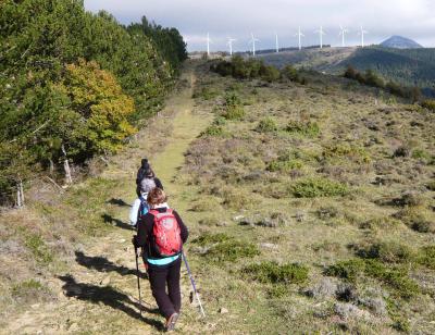
Hiking
-
Biking
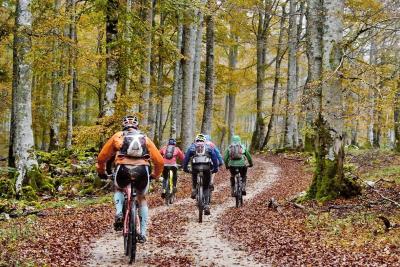
Biking
-
Adventure parks
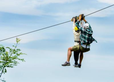
Adventure parks
-
Rural tourism
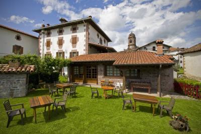
Rural tourism
-
Way to St James
Way to St James